Projects
PhD Project
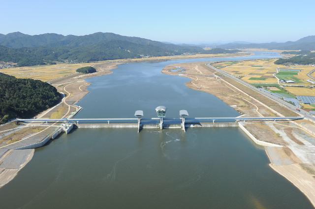
Title: Application of Diatom Analysis to Water Quality Assessment. Case Study: The Nakdong River in the Republic of Korea (View thesis)
- Introduction
The Nakdong River, one of the largest rivers in the Republic of Korea, has been a main source of water to more than 6 million residents in the southeast part of Korea. As a part of Four Major Rivers Restoration Project which was implemented from 2009 to 2012, eight barrages have been constructed along the river and are regulating the river flow. However, despite the fact that the environmental impact would have been significant on the river, little research has been carried out about how the construction of the barrages has made impacts on the river and its ecosystems.
- The aim of the project
The aim of the project is to exmaine changes in the water quality and diatom assemblages in relation to the construction of the barrages along the Nakdong river.
- Research questions
1. How has water quality (WQ) changed through time?
2. How have diatom assemblages responed to changes in WQ through time?
3. Are diatom-based approaches useful in demonstrating changes in the datasets through time?
4. What are the relationships between WQ + diatom samples and WQ + secondary data?
5. Is diatom analysis reliable enough for water quality assesment?
6. What are the differences in the relationships obtained in Q4 and are there any speices and/or relationships that can be used to better assess the health of rivers?
Master Project
Title: Paleoenvironmental change and Geomorphological development during the Holocene near Susanje artificial bank, Miryang (in Korean) (View thesis)
- Introduction
The study area, near Susanje, Miryang is known as a location with one of the anciently built irrigation facilities for agriculture along with Byeokgolje near Gimje and Uirimji near Jecheon. This region is located on an alluvial plain in the downstream Nakdong river. Susanje, the artificial bank had not attracted public attention until a local historian, Mr. Son Jung-tae, found its floodgate in 1986. Since then, many researchers, especially archaeologists and historians, have been investigating its origin, role and time of construction through historical and archaeological methods. However, due to lack of historical data, finding the critical evidence of anciently built irrigation facilities has been difficult. Very little about Susan irrigation facilities has become clear even with the ongoing studies. Therefore, the need for new methods to approach this facility, in addition to historical and archeological methods, has arisen.
- The aim of the project
This study aims to 1) reconstruct a sea level curve for the Holocene in Susan using sediment analysis, diatom analysis and radiocarbon dating, 2) restore the paleo-environment and paleo-topography in Susan based on a sea-level curve and an old-topography map as well as preceding research data and thus create topography maps showing the stages of primary change by time series, 3) discuss the role and construction time of Susan irrigations facilities based on the results of this study.